Columbus Plans 3-Mile East Side Rail Trail to Link Neighborhoods, Parks and Rapid Transit
The Eastmoor Green Line will transform a disused 3-mile rail corridor into a 17.5-acre linear park connecting East Main Street rapid transit, neighborhood schools and arterial street crossings.
A long-dormant transportation corridor on the East Side of Columbus is moving closer to active community life. Columbus Recreation and Parks is advancing plans to turn an abandoned railroad right-of-way between Bexley and Whitehall into a three-mile linear park and shared-use trail known as the Eastmoor Green Line.
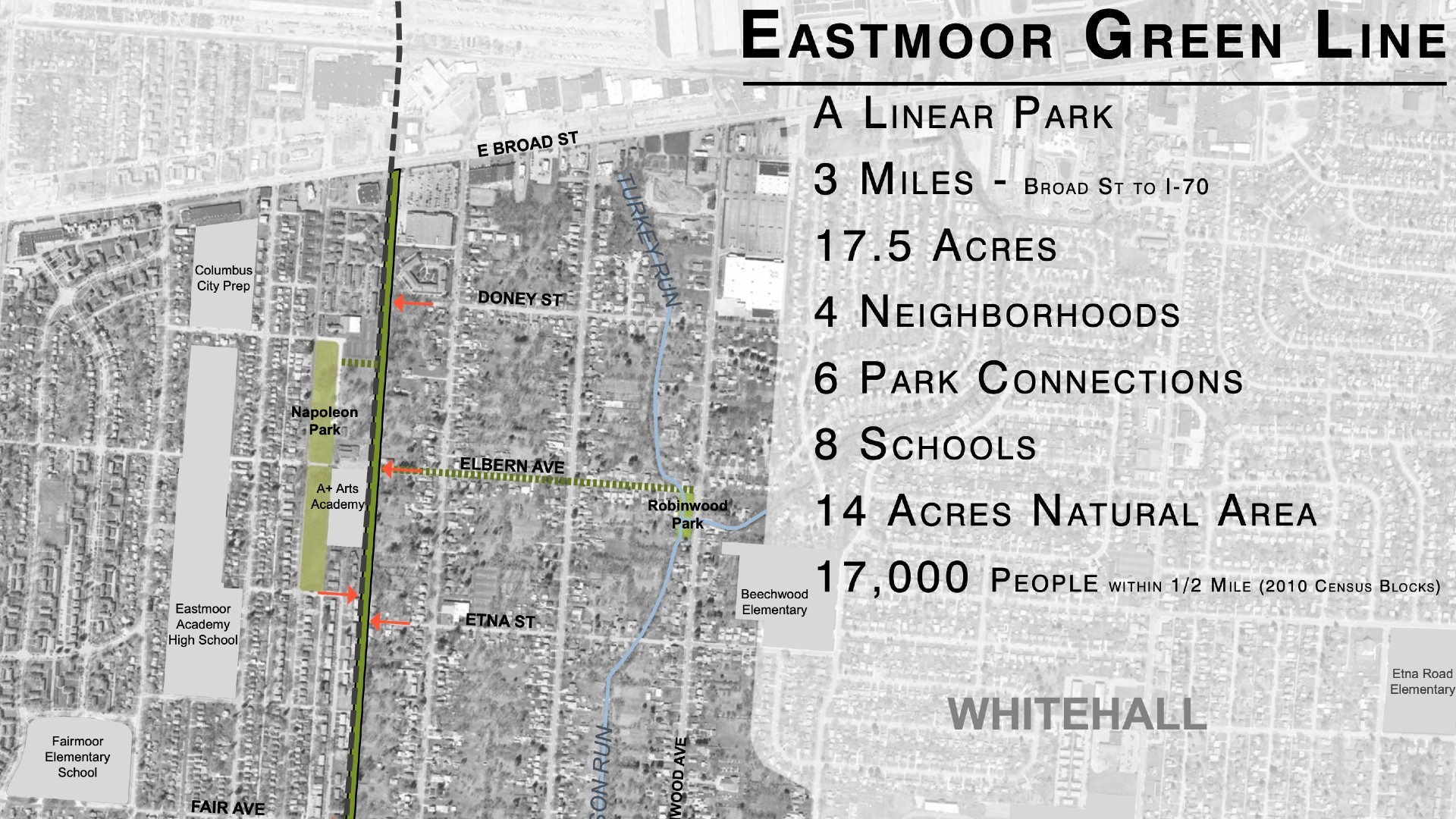
Running from East Broad Street south to Interstate 70 along Whitehall's western border, the three-mile trail corridor will repurpose an industrial remnant that has sat unused since the 1980s. With tracks pulled up decades ago, city planners envision a vibrant, 17.5-acre recreational and non-motorized commuting spine that connects residential subdivisions, public schools, municipal parks and regional public transit lines across Central Ohio.
Rail Corridor Acquisition and LinkUS Capital Investment
The land acquisition process represents the culmination of multi-year efforts by city officials to assemble discontinuous open space on Columbus's East Side. The City of Columbus completed the purchase of the abandoned rail corridor to establish municipal control over the entire 17.5-acre linear footprint.
Brad Westall, Greenways Planner for the Columbus Recreation and Parks Department, noted that the disused rail corridor had lingered without purpose for decades after rail operations ceased.
"It's just laying there derelict, it has no function," Westall said. "What we will do, once we own this site, we'll begin to restore it with native plantings, meadow plantings and pollinator gardens."
Capital planning for the greenway aligns municipal park improvements with broader regional transit initiatives. The project has secured $1.7 million in LinkUS funding allocated for construction, supported by the regional mobility program. That funding stream follows voter support in November 2024, when 57% of voters approved the LinkUS ballot measure across the Central Ohio Transit Authority (COTA) service area to expand transit and active-transportation infrastructure.
Stephanie Garling, Communications and Marketing Manager for the Columbus Recreation and Parks Department, said that the department scheduled preliminary design plans and public engagement sessions to refine the linear park's engineering features leading toward construction.
Multimodal Integration With East Main Street Bus Rapid Transit
A pivotal element of the trail’s design is its direct interface with regional public transit. The rail trail crosses East Main Street, establishing a key multimodal transfer junction with the planned LinkUS East Main Street Bus Rapid Transit (BRT) line.
The East Main Street BRT corridor will stretch eight miles from Downtown Columbus through Bexley and Whitehall to Reynoldsburg. Designed with 17 planned stations and dedicated bus lanes, the rapid transit route aims to reduce travel times and expand access to employment centers and healthcare facilities for East Side residents.
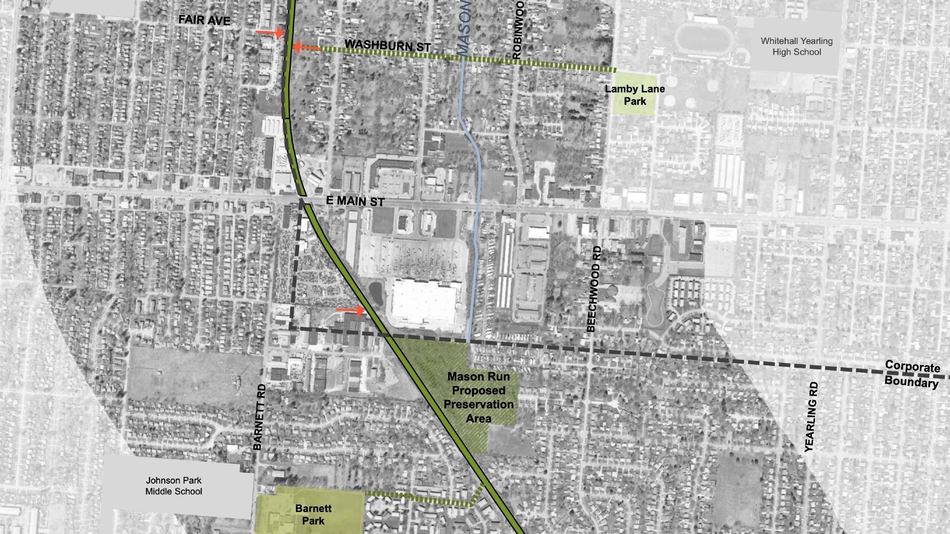
By bridging the north-south gap between East Broad Street and Interstate 70, the Eastmoor Green Line functions as an active first-mile and last-mile connector for neighborhood commuters. Cyclists and pedestrians living north or south of East Main Street will be able to travel along a traffic-separated path directly to the nearest BRT station, creating seamless transfers between non-motorized travel and high-capacity public transportation.
Neighborhood Revitalization and Park Connectivity
Beyond its mobility functions, the linear park serves as a community revitalization asset for adjacent neighborhoods. The trail corridor averages 80 feet in width, providing ample space for small park installations and natural restoration alongside the paved multi-use pathway.
The trail passes directly alongside Napoleon Park, a 6.181-acre neighborhood park located in the Mid East community on South Napoleon Avenue. Master planning along the trail corridor integrates access to local schools—including Eastmoor Academy High School and A+ Arts Academy—giving students safe, off-street routes to walk and bike to class.
Recreation and Parks officials also identified a 14-acre wooded parcel along the corridor for preservation as a natural area. The greenway is designed to link into local trail networks connecting toward Robinwood Park and broader regional routes toward Big Walnut Creek.
The corridor's development parallels surrounding neighborhood revitalization efforts, including brownfield remediation. Directly bordering the rail corridor at 3515 E. Main St., LDG Development is building a 316-unit affordable housing complex on the 15-acre former Wirthman Brothers Salvage Yard site, with units reserved for households earning 60 percent of area median income.
Westall highlighted that the linear park design allows the city to build neighborhood-scaled spaces directly where families live.
"These linear parks form a way to not only walk and bike and have that activity that a trail provides, they also provide places for us – Recreation and Parks – to develop small-scale amenities," Westall said. "Small play-scapes, gathering areas, a little shelter for families…this runs right through the heart of a neighborhood."
The City of Whitehall is partnering with Columbus on cross-jurisdictional coordination, ensuring trail access points and civic spaces serve residents on both sides of the municipal boundary.
Arterial Crossing Safety and the 2028 Milestone
Navigating the East Side's street grid presents the project's most significant engineering considerations. The greenway must safely guide pedestrians and cyclists across three major, high-volume east-west arterials: East Broad Street, East Main Street and East Livingston Avenue.
Historically designed primarily for vehicular throughput, these multi-lane roadways have presented barriers for non-motorized travel. The Eastmoor Green Line engineering plan incorporates dedicated crossing infrastructure, including high-visibility crosswalk markings, pedestrian-activated signals, and refuge islands to ensure safe passage.
City planners are progressing through detailed engineering and inter-agency coordination with transit and roadway authorities. Following corridor design and utility clearance, Phase 1 construction is scheduled to begin in 2028, delivering the first segment of a long-awaited active transportation connection for Columbus and Whitehall residents.
How we know this
The sources and records behind this story, with the facts they support.
https://columbusunderground.com/new-linear-park-and-trail-planned-for-east-side-bw1/
Supporting evidence (9)
Columbus Recreation and Parks is advancing plans to turn an abandoned railroad right-of-way between Bexley and Whitehall into a three-mile linear park and shared-use trail known as the Eastmoor Green Line.
Read supporting passage
To be called the Eastmoor Green Line, the trail will run along Whitehall’s western edge, starting at East Broad Street and extending three miles to the south, where it will dead-end at I-70.
Running from East Broad Street south to Interstate 70 along Whitehall's western border, the three-mile trail corridor will repurpose an industrial remnant that has sat unused since the 1980s.
Read supporting passage
To be called the Eastmoor Green Line, the trail will run along Whitehall’s western edge, starting at East Broad Street and extending three miles to the south, where it will dead-end at I-70.
With tracks pulled up decades ago, city planners envision a vibrant, 17.5-acre recreational and non-motorized commuting spine that connects residential subdivisions, public schools, municipal parks and regional public transit lines across Central Ohio.
Read supporting passage
Brad Westall, Greenways Planner for the Recreation and Parks Department, said that the city is in the process of acquiring the former rail right-of-way and will likely have control of the land by this summer. Last used as an active railway in the 1980s, the tracks were pulled up years ago.
"It's just laying there derelict, it has no function," Westall said.
Read supporting passage
“It’s just laying there derelict, it has no function,” he says. “What we will do, once we own this site, we’ll begin to restore it with native plantings, meadow plantings and pollinator gardens.”
The trail corridor averages 80 feet in width, providing ample space for small park installations and natural restoration alongside the paved multi-use pathway.
Read supporting passage
The next step is to build the trail itself and to develop a series of small parks along the route – at an average of 80 feet in width and totaling 17.5 acres, there will be enough space to accommodate more than just a shared use path.
Recreation and Parks officials also identified a 14-acre wooded parcel along the corridor for preservation as a natural area.
Read supporting passage
The new trail will cross East Main Street and East Livingston Avenue and will be within walking distance of several existing parks. A 14-acre, mostly wooded parcel of land that also sits along the route is being eyed as a potential nature preserve.
"These linear parks form a way to not only walk and bike and have that activity that a trail provides, they also provide places for us – Recreation and Parks – to develop small-scale amenities," Westall said.
Read supporting passage
“These linear parks form a way to not only walk and bike and have that activity that a trail provides, they also provide places for us – Recreation and Parks – to develop small-scale amenities,” Westall says. “Small play-scapes, gathering areas, a little shelter for families…this runs right through the heart of a neighborhood.”
The City of Whitehall is partnering with Columbus on cross-jurisdictional coordination, ensuring trail access points and civic spaces serve residents on both sides of the municipal boundary.
Read supporting passage
The City of Whitehall is also a partner in the project.
The greenway must safely guide pedestrians and cyclists across three major, high-volume east-west arterials: East Broad Street, East Main Street and East Livingston Avenue.
Read supporting passage
The new trail will cross East Main Street and East Livingston Avenue and will be within walking distance of several existing parks. A 14-acre, mostly wooded parcel of land that also sits along the route is being eyed as a potential nature preserve.
https://columbusunderground.com/housing-planned-for-green-line-adjacent-industrial-site-bw1/
Supporting evidence (4)
The City of Columbus completed the purchase of the abandoned rail corridor to establish municipal control over the entire 17.5-acre linear footprint.
Read supporting passage
The eastern edge of the Wirthman site borders an abandoned rail corridor that the City of Columbus has purchased and plans to turn into a three-mile-long linear park and trail that will be called the Eastmoor Green Line
The project has secured $1.7 million in LinkUS funding allocated for construction, supported by the regional mobility program.
Read supporting passage
Stephanie Garling, Communications and Marketing Manager for the Columbus Recreation and Parks Department, said that the project has received $1.7 million in LinkUS funding for 2027 that will go toward construction.
Stephanie Garling, Communications and Marketing Manager for the Columbus Recreation and Parks Department, said that the department scheduled preliminary design plans and public engagement sessions to refine the linear park's engineering features leading toward construction.
Read supporting passage
Stephanie Garling, Communications and Marketing Manager for the Columbus Recreation and Parks Department, said that the project has received $1.7 million in LinkUS funding for 2027 that will go toward construction.
Main St., LDG Development is building a 316-unit affordable housing complex on the 15-acre former Wirthman Brothers Salvage Yard site, with units reserved for households earning 60 percent of area median income.
Read supporting passage
plans to build a 316-unit apartment complex on the parcel. The project will contain a mix of one-, two- and three-bedroom apartments, and will be affordable for tenants earning 60 percent of the area median income
https://linkuscolumbus.com/eastmain/
Supporting evidence (3)
That funding stream follows voter support in November 2024, when 57% of voters approved the LinkUS ballot measure across the Central Ohio Transit Authority (COTA) service area to expand transit and active-transportation infrastructure.
Read supporting passage
In November 2024, the LinkUS initiative passed with approval from 57% of voters in the COTA service area, securing the funding needed to move the project forward.
The East Main Street BRT corridor will stretch eight miles from Downtown Columbus through Bexley and Whitehall to Reynoldsburg.
Read supporting passage
The East Main Street Bus Rapid Transit (BRT) line will run eight miles from Downtown Columbus to Reynoldsburg, featuring 17 stations, dedicated bus lanes, sidewalks and community amenities to improve connectivity and access.
Designed with 17 planned stations and dedicated bus lanes, the rapid transit route aims to reduce travel times and expand access to employment centers and healthcare facilities for East Side residents.
Read supporting passage
The East Main Street Bus Rapid Transit (BRT) line will run eight miles from Downtown Columbus to Reynoldsburg, featuring 17 stations, dedicated bus lanes, sidewalks and community amenities to improve connectivity and access.
https://columbusrecparks.com/parks/napoleon-park/
Supporting evidence (1)
The trail passes directly alongside Napoleon Park, a 6.181-acre neighborhood park located in the Mid East community on South Napoleon Avenue.
Read supporting passage
Napoleon Park is a 6.181-acre neighborhood park in the Mid East community.